
SÍGUENOS EN LAS REDES


International River
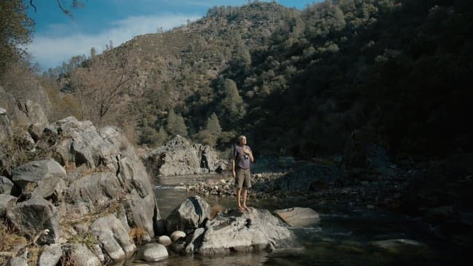
🎬Watch, ‘The Voice of a River’, a new short film about co-founder of International Rivers’ and first international #EarthDay co-organizer Mark Dubois.
👉https://youtube.com/watch?v=OQkEC08nTI8&ab_channel=MyGreenPod
Would you risk your life to save a river? This man did. #RiversUniteUs #EarthWeek
In 1979, Mark Dubois chained himself to a rock behind New Melones Dam in the USA’s Stanislaus River Canyon and threw away the key. This was no empty gesture: if the Army Corps of Engineers continued to fill the reservoir, Mark would drown. 42 years later, Mark’s story has been told in a short film released for Earth Day 2021. It’s hoped The Voice of a River, created by Citrix Systems and My Green Pod, and produced by Carlos Gonzalez, will remind everyone that one person’s actions can make lasting positive change. Competition Details The winner of our Earth Day competition will have 500 trees planted in their name, plus a certificate to say thank you! The trees will be planted in the tropics, through charity partner TreeSisters. To be in with a chance of making a huge difference to reforestation efforts, visit My Green Pod on Twitter, Instagram or Facebook for more information on how to enter. Good luck! Subscribe to the My Green Pod Newsletter: https://www.mygreenpod.com/subscribe/ Socials Facebook: My Green Pod Instagram: @mygreenpod Twitter: @mygreenpod LinkedIn: My Green Pod My Green Pod Ltd is an independent, family-run UK business, founded by Katie Hill and Jarvis Smith. Our YouTube channel is a portal where you can learn how to live sustainably using content from the UK’s biggest ethical lifestyle magazine.

23 abr. 2021 – 9:00 p. m.
Por: Redacción Internacional
La guerra por el agua es una realidad en África. Egipto y Sudán se oponen a una represa que quiere construir Etiopía y que podría reducir el agua que les llega del río Nilo.

https://buy.tinypass.com/checkout/template/cacheableShow?aid=ZUhps7eupu&templateId=OT27SSDEWIUA&offerId=fakeOfferId&experienceId=EX4TS7T4NKCI&iframeId=offer_0d7a41da86c9864ad2e6-0&displayMode=inline&pianoIdUrl=https%3A%2F%2Fid.tinypass.com%2Fid%2F&widget=template


International Rivers
📣Join us and our partners for a #RightsOfRivers event!

The #BalkanRivers are some of the last #free-flowing rivers of #Europe and are a hotspot for #biodiversity. These rivers are now being threathened by plans to build over 2,500 dams! #StopTheDams
Keynote speaker:
Monti Aguirre, Latin America Program Coordinator, International Rivers Register
The Balkan rivers are some of the last free-flowing and wild rivers of Europe and are a hotspot for biodiversity with unique ecosystems and wildlife, including the critically endangered Balkan lynx. They are home to 69 different fish species that live nowhere else in the world, and their beds provide shelter for over 40% of all endangered freshwater mollusk species in Europe.
However, those rivers are now highly endangered with the plans to build over 3,000 dams on just about every one of them. If built, it would possibly result in nearly one in ten of Europe’s fish species being pushed to the brink of extinction with eleven endemic species being wiped out, seven more would be critically endangered, four types of sturgeon would be devastated and the number of endangered species would double to 24, according to the University of Graz report. Deforestation and soil erosion will follow, along with irrevocable changes to the course and character of untamed rivers, a quarter of which lie in pristine national parks and protected areas
That’s why, groups are mobilizing to campaign for the dams to be classed as #ecocide, for the recognition of the Rights of Rivers to be healthy and free-flowing, for the dams to be taken out of any ‘renewable’ energy policies, for the subsidies to be immediately stopped and for the dams to be taken out and rivers returned to their full health. More information
International Rivers

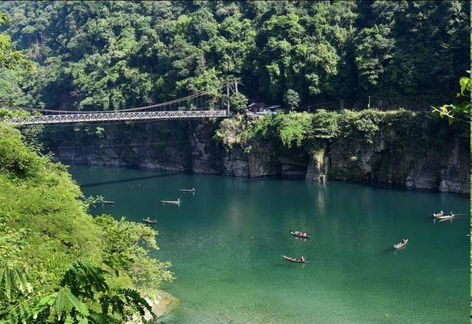
📌Great to see the organized resistance coming together against hydroelectric developments on the Umngot River! Dams disrupt the pristine ecosystems, harm local economies, and displace communities.
It’s time to #StopTheDams!
#RiversUniteUs #UmngotRiver
Traducido del inglés
📌¡Es genial ver cómo la resistencia organizada se une contra los desarrollos hidroeléctricos en el río Umngot! Las represas alteran los ecosistemas prístinos, dañan las economías locales y desplazan a las comunidades.
Es tiempo de #StopTheDams !
International Rivers

Happening now! Join in on the important and timely «Global Just Recovery» online event! You can register here: https://justrecoverygathering.org
Also, check out our work in topic of a #justrecovery 👉 https://rivers4recovery.org

International Rivers
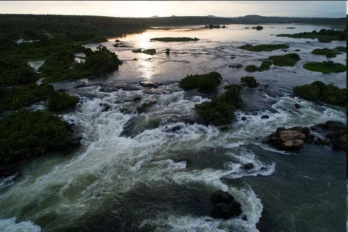
📣Concerned about endangered freshwater ecosystems? We are too! Here’s some good news: removing dams is one of the best ways to restore these critical populations!
Check out this exciting story here: 👉http://ow.ly/2JSr50EoSzY
International Rivers
📌So great to see #damremovals happening around the world! These are critical steps to restoring freshwater ecosystems, preventing further climate destruction and more!
📌Learn more about recent efforts in Catalonia, Spain here: 👉 http://ow.ly/dEKq50EfKSB
By Dam Removal Europe April 1, 2021
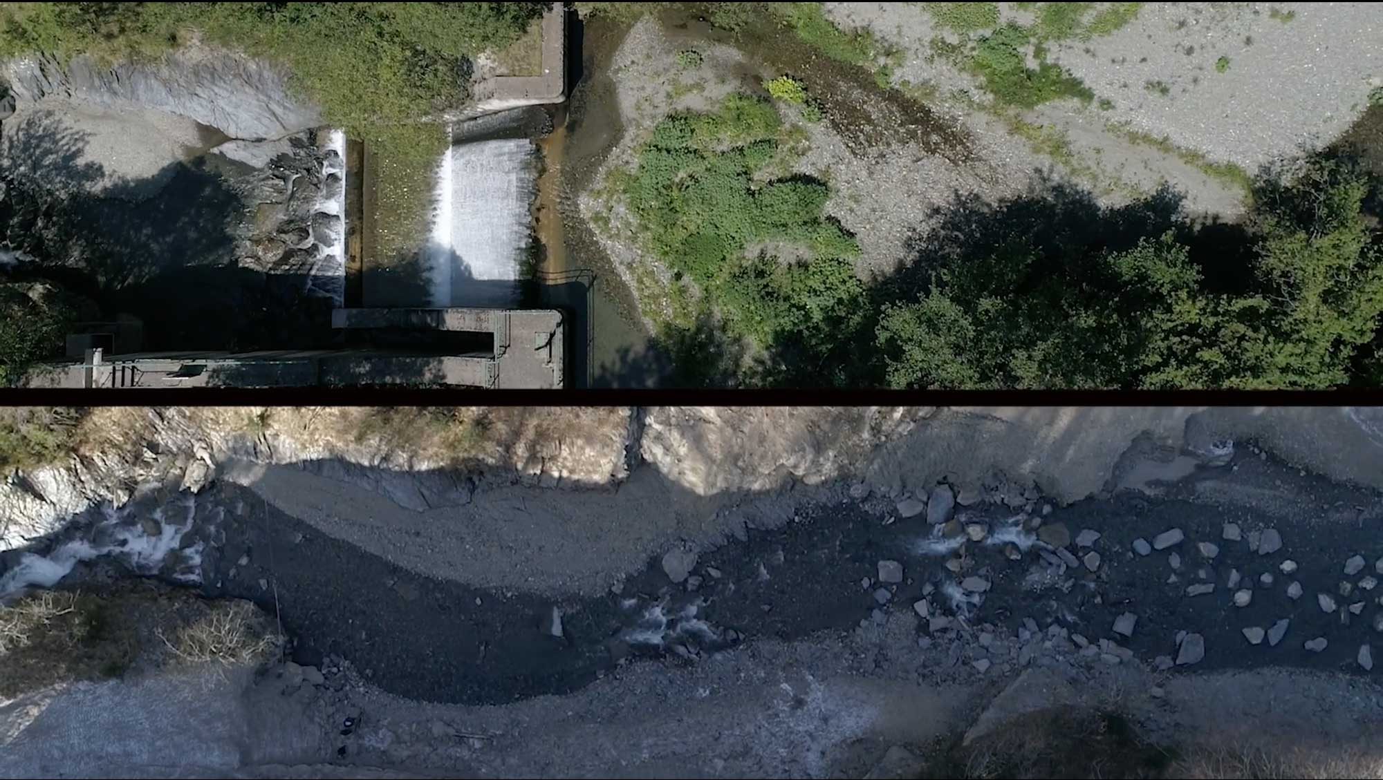
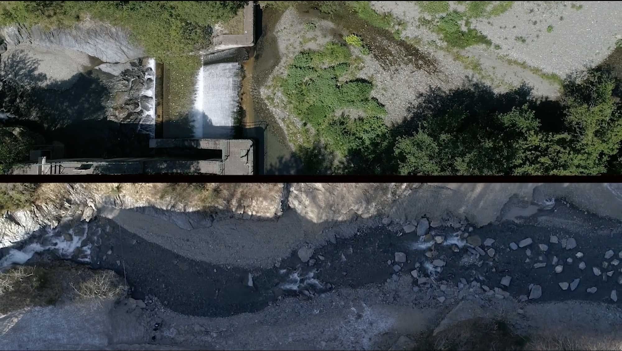
The Molló (also known as Ritort) dam was located at the top of the Ritort River in the Catalonian region of Spain. The dam was built in 1991, and was 7 meters high by 24 meters wide. For many years, the Molló dam served to retain and divert water to the Ritort hydroelectric plant, thus breaking the connectivity of the river.
The decision to demolish the dam and restore connectivity in this stretch of the river has made a new reality possible.
Demolition works began in late August 2020 and were completed in early November of the same year. The video below, created by the Catalan Water Agency, shows the initial state of the river, the start and development of the works, and the final visual result of the environment once the action was carried out. Practitioners used a zipline system for the dam removal. 8 km of river were opened in a river that is a Natura 2000 network space and a trout genetic reserve.
This demolition, which is part of the Green Agenda of Catalonia, was carried out by Infraestructures.Cat with the direction and coordination of the Department of Territory and Sustainability, and the Catalan Water Agency. The local community has responded favorably.
Note: The video below is in Catalán, but has the option to automatically translate the subtitles into your preferred language. https://www.youtube.com/embed/wZBUmF39zaw?feature=oembed
by Michele Thieme on 30 March 2021
This past December marked the 5th anniversary of the landmark Paris Agreement. Soon after, the Biden Administration rejoined the Paris Agreement as one of their first actions in office. And in January, the Climate Adaptation Summit once again convened global leaders and local stakeholders to accelerate adaptation action.
As these milestones reinvigorate a call to action for our politicians and business leaders to act on climate and “ramp up climate ambition,” all eyes inevitably turn to the usual avenues for addressing and adapting to climate change: forests, clean energy and waving goodbye to our toxic relationship with fossil fuels. And while mitigation efforts continue to dominate the conversation, adaptation is ever-increasing in importance in global discussions as extreme weather and its impacts worsen around the world and countries work to build stronger national commitments.
Funding, policies and actions supporting adaptation, especially nature-based solutions, however, remain weak. They overlook a powerful resource in the fight to adapt to a changing climate: rivers.
We are seeing the climate crisis manifest through water. Droughts and floods are increasing in frequency and severity from the Mekong River to the arid Rio Grande, from the plains of Africa to the world’s largest tropical wetland, South America’s Pantanal.
Rivers and their floodplains have the potential to act as shock absorbers to climate change. But maximizing their ability to do so requires strategic interventions that keep their natural features intact or incorporate green and grey infrastructure that allow natural processes to occur. Governments and business leaders must prioritize climate adaptation actions that include rivers as part of the toolbox of nature-based solutions for solving the climate crisis.

Rivers: Unsung heroes of climate adaptation
Rivers are powerful agents for keeping wildlife and communities healthy and resilient. Their natural functions provide life-giving resources and, critically for sinking deltas around the world, protect coastal areas against rising sea levels. Let’s dive deeper on a few of these functions:
See related: Review all of Mongabay’s features on solutions to challenges like climate change here.

Current state of affairs
When rivers are able to flow naturally and are not impeded by infrastructure, like dams, we call these “free-flowing” rivers. They are vital to supplying climate adaptation services, but increasingly, human activities are severing rivers. This decline in river health is sounding alarms to freshwater scientists everywhere:
Rivers and their floodplains lose the ability to buffer against floods and to deliver needed sediments to downstream deltas as they are fragmented. The Mekong River illustrates a harsh reality communities face when infrastructure is poorly planned.
The Mekong Delta is currently shrinking and sinking, having lost about 500 hectares of land in the decade leading up to 2012. While sea-level rise and groundwater extraction play a role, the immediate major causes of higher tides and salt intrusion in the delta are sand mining and trapping of sediments behind upstream dams.
Additional planned dams within the Mekong Basin will further exacerbate this problem, putting the tens of millions of people living in the delta at even greater risk for increased land loss, flooding and inundation.
In one hopeful measure, the Cambodian government has put a 10-year moratorium on any new dams on the main stem of the Mekong in Cambodia.
See related: How Vietnam came to embrace a new vision of the Mekong Delta’s future

Wins to build on
Countries from around the world and other members of the International Union for Conservation of Nature (IUCN) recently signed up to support the motion, ‘Protecting rivers and their associated ecosystems as corridors in a changing climate.’ This sets an important precedent for incorporating river protection into climate action policy.
There are a few other bright spots where governments and civil society are taking action to ensure that rivers and their floodplain and riparian zones can continue to act as corridors and buffers in a changing climate. One example is the recent action of the Colombian government to designate the entire free-flowing Bita River Basin as a Ramsar site, i.e. an internationally protected wetland. Another example is Mexico’s decrees for water reserves across nearly 300 basins that have effectively protected against over-extraction of water or blocking of river flows in some of the most intact basins of the country.
In Mongolia, the government has recently revised and approved 8.2 million hectares of water protection zones including riparian areas from mining and industrial development across seven provinces and is replicating this process in six additional provinces. In the U.S., the Wild & Scenic River designation has so far protected 13,413 miles of 226 rivers in 41 states. And this past autumn, U.S. environmental groups and the hydropower industry signed a joint statement to collaborate on river restoration and decarbonizing US electricity.
The burgeoning efforts to restore rivers began in the United States and have now spread to Europe, where the recent commitment of the European Union to dismantle dams and open up 25,000 km of rivers provides another compelling example. The “Room for the River” initiative of the Dutch government has taken measures at more than 30 locations along the Rhine, the Meuse, the Waal, and the Ijssel to give these rivers space to flood safely.
This progress is evidence that actions that allow rivers to act as corridors and buffers to build resilience in a changing climate are possible and that there is opportunity to replicate these wins.
A path forward
Humanity has always depended on the life-giving resources that rivers provide. As our global temperatures rise, people will be more dependent on rivers than ever before – both in terms of the benefits that they provide and the havoc they can bring if not well managed.
We cannot afford to continue to destroy one of our tools in the fight to adapt to climate change. Rivers need a seat at the table. The best-laid climate action plans will be those that account for the nature-based solutions rivers and floodplains provide in adapting to a changing climate. Business and policy leaders can incorporate rivers into their plans to support the flow towards a climate-resilient future.
When we think of climate solutions, let’s also think of rivers.
Michele Thieme is lead freshwater scientist at World Wildlife Fund (WWF).
Related listening from Mongabay’s podcast: Goldman Prize winner Ana Colovic Lesoska discusses the campaign to stop a dam-building spree in southern Europe, listen here: https://html5-player.libsyn.com/embed/episode/id/17901296/height/90/theme/custom/thumbnail/yes/direction/backward/render-playlist/no/custom-color/3e5014/time-start/00:28:52 Article published by Erik Hoffner
29/03/2021

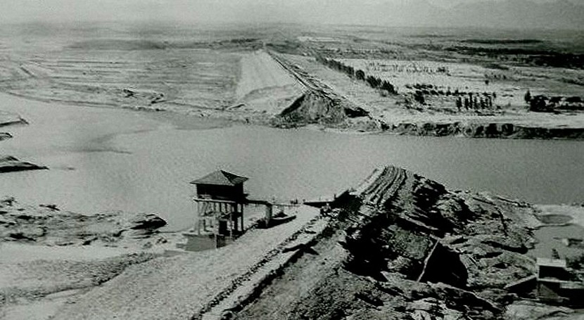
El 4 de agosto de 1975 el tifón Nina toca tierra en China. 4 días después se rompe la presa de Banqiao generando una avenida de seis metros de alto por 12 kilómetros de ancho a 50 kilómetros por hora. Al día siguiente el balance (según los medios oficiales) es de 62 presas destruidas -algunas de ellas bombardeadas a propósito-, 26.000 muertos, que se convertirían en más de 100.000 mil por las hambrunas, y más de un millón de personas sin hogar.
Esta es la poco conocida tragedia de la presa de Banqiao. Una historia de cómo la falta de previsión, gestión y mantenimiento, junto a las mayores lluvias registradas en la zona, dieron lugar a una reacción en cadena que acabo con la vida de entre 125.000 y 230.000 personas. Es la mayor tragedia registrada asociada a una infraestructura humana en la historia.
Debido a una meteorología inusual, el tifón Nina, en lugar de perder fuerza al tocar tierra, se incrementó, atravesando las provincias de Jiangxi y Hunana, girando luego hacia el norte hasta el río Yangtze y las planicies centrales de China. El 5 de agosto el tifón volvió a girar hacia el oeste y se cruzó la provincia de Henen hacia las presas de Banqiao y Shimantan.
El tifón estuvo por lo tanto dos días estacionario sobre la misma zona descargando en 24 horas más lluvia que en todo un año, batiendo registro de lluvia en una hora, 189.5 mm, y en un día, 1060 mm, cuando la media en la zona es de 800 mm al año.

La presa de Banqiao se terminó de construir en junio de 1952. Debido a los bajos estándares chinos en diseño y construcción por esa época, no tardaron en aparecer grietas en el cuerpo y en las compuertas. Por ello se acudió a la Unión Soviética en 1954 cuyos ingenieros reforzaron la presa, al igual que ocurriría con la presa de Shimantan. Al nuevo diseño se le denominó como “presa de hierro” porque consideraban, erróneamente como ya veremos, como irrompible.

La presa de Banqiao tenía una capacidad de almacenaje máxima de 492 millones de m3 y la de Shimantan de 94.4 millones de m3 y ambas eran presas de gravedad de materiales sueltos.
Ninguna de ellas estaba diseñada para gestionar una lluvia de tales características, con un periodo de retorno aproximado de 2000 años.
La zona venía de un periodo largo de sequía, por lo que unas buenas lluvias servirían para almacenar agua para un futuro. Ese afán o necesidad por almacenar agua, fue el primero de los problemas.
Ese día las lluvias registradas en la zona llegaron a los 448 mm, rompiendo un primer récord, y comenzaron las inundaciones en la zona. A las presas de la zona empezaron a llegar grandes caudales y sus niveles a subir.
El 6 de agosto estuvo lloviendo durante 16 horas, y aunque se solicitó abrir las compuertas para aliviar agua, el permiso se denegó porque aguas abajo ya había inundaciones. El nivel de la presa de Banqiao se situó 2 metros por encima del Nivel Máximo de Explotación (NME).
Finalmente el permiso fue concedido, pero los telegramas no llegaban a la presa de Banqiao porque las infraestructuras estaban dañadas. Mientras tanto, otra lluvia de 13 horas caía sobre la zona.
Cuando se intentaron abrir los aliviaderos de Banqiao y Shimantan se encontraron que estaban parcialmente bloqueados por sedimentos y las avenidas los habían dañado haciendo muy difícil su apertura, no solo por las lluvias sino por avenidas provenientes de otros diques aguas arriba que iban colapsando.
Incluso operarios declararon que se valoró volar parte de los aliviaderos para aumentar su capacidad, pero que tenían pocos materiales porque los últimos años se había reducido mucho la inversión en prevención de inundaciones debido a la sequía.
A las 09:30 PM una unidad de Ejército Popular de Liberación chino que había sido desplegado en la presa de Banqiao mandó el primer telegrama de alerta de fallo de la presa. A las 11:30 PM, pese al esfuerzo del ejercito por colocar sacos de arena en la coronación de la presa, esta se desbordó. Y lo mismo estaba pasando en la presa de Shimantan.
Recordemos que las presas eran de materiales sueltos, por lo que, si el agua empieza a pasar por encima de ella, se la llevaría por delante.
A las 12:30 AM se rompe la presa de Shimantan. 20 millones de metros cúbicos se vaciaron con un caudal punta de 25.300 m3 por segundo vaciándola en 5 horas.
A la 1:00 AM se rompe la presa de Banqiao cuando almacenaba 600 millones de m3 de agua. El embalse tardó seis horas en vaciarse y generó una avenida de 6 metros de alto por 12 kilómetros de ancho que destruyó todo a su paso a una velocidad de 50 km/h.

Se generó aguas abajo un lago de 300 x 150 km porque el agua no encuentra salida. La zona, que históricamente había sido una llanura de inundación natural, debido a su intenso cultivo y el aporte de sedimentos al río, había reducido enormemente su capacidad de drenaje.

Para proteger otras presas del colapso, algunas áreas fueron evacuadas e inundadas a propósito, llegando a realizar ataques aéreos para destruir algunas presas y evacuar el agua en ciertas direcciones.
Con los diques del río colapsados, la presa de Baoshnan a punto de desbordarse y el Lago Suya almacenando 1.200 millones de m3 de agua (los que había almacenado él más los provenientes de Banqiao y Shimantan) a punto de desbordarse, se decidió continuar con los ataques aéreos para evitar una catástrofe aún mayor si cabe.
En total fueron 62 las presas que se rompieron por la acción del agua o que fueron bombardeadas deliberadamente.

El secretismo con el que se llevó todo lo relacionado con la tragedia por parte del gobierno chino hace que hasta hoy en día se dude del impacto real que tuvo.
Según el gobierno chino en el desastre murieron 26.000 personas directamente y 145.000 por las epidemias y hambrunas posteriores. Se inundaron 29 condados y 1.140.000 hectáreas afectando a 5.900.000 edificios.


La principal causa de la tragedia sin duda fueron las excepcionales lluvias. Pero otras muchas cosas que se hicieron mal durante años desembocaron en todos estos acontecimientos.
Durante el periodo denominado como el gran salto adelante, China, desde 1958 a 1962, realizó una importante campaña para transformar su economía agraria tradicional a través de una rápida industrialización y colectivización. En la zona esto supuso, entre otras medidas, dar mayor importancia a la irrigación y acumulación de agua en las presas, que al control de avenidas.
De las nueve puertas de los aliviaderos de emergencia del diseño original de la presa de Banqiao se redujeron hasta siete y en 1961 se inutilizaron dos más para dar preferencia a la acumulación. Esto pasó también con otras presas.
El poco mantenimiento tenía aterradas parcialmente los aliviaderos de emergencia y sus sistemas de apertura no eran lo suficientemente robustos, por lo que no podía controlar eficazmente las avenidas.
La capacidad de desagüe de los ríos aguas abajo de las presas se había reducido mucho por la agricultura intensiva que había ocupado cauces y los había llenado de sedimentos. Se había cambiado tanto la morfología de los cauces que el agua no encontraba sitio para pasar.
Las inundaciones afectaron a las comunicaciones telefónicas y de carreteras, por lo que no se podían comunicar con las estaciones meteorológicas ni entre sí para coordinar las actuaciones. Las comunicaciones también fallaron para alertar a la población y poder evacuar a las zonas más afectadas.
En el momento de la tragedia, llevaban tres años sin celebrarse las reuniones anuales de control de inundaciones para los encargados de la gestión de las presas, en parte por la gran sequía que llevaba varios años azotando a la zona, y no había directrices claras de cómo actuar en esos casos, según cuentan sus trabajadores.
Y aun así, la presencia de las presas posiblemente salvaron muchas vidas, pues dieron tiempo a evacuar a parte de la población y a qué otra parte estuviera alertada. Desde las primeras lluvias torrenciales hasta que las presas se rompieron, pasaron 3 días.
Afortunadamente casos como estos se han dado pocos en el mundo y cada vez son más improbables, pues los estándares de construcción, mantenimiento y gestión de las infraestructuras son mucho mayores. Las comunicaciones son mucho más sofisticadas y los sistemas de decisión en caso de avenidas están muy evolucionados.
No vamos a descubrir ahora lo esenciales que son estas infraestructuras para el desarrollo del ser humano, para dar de comer y beber a las personas, para darles electricidad y para salvarles la vida en caso de lluvias intensas.
Sirva esta historia para recordar la necesidad de unas infraestructuras seguras, bien diseñadas y bien mantenidas. Y para reconocer la labor de todos aquellos que lo hacen posible día a día.
Bibliografía:
Imágenes